Search Constraints
Search Results
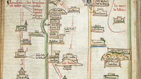
Select an image to start the slideshow

Pelagios Project: Maps after Ptolemy's Geographia. Burney MS 111
1 of 19

Pelagios Project: Digitised Liber insularum Arcipelagi Cotton MS Vespasian a.XIII.art.1
2 of 19

Pelagios Project: Digitised Insularium Illustratum. Additional MS 15760
3 of 19

Pelagios Project: Liber insularum Cycladum. Arundel MS 93.art.7
4 of 19
Pelagios Project: Single Sheets and Supplementary Materials
5 of 19

OCR text derived from digitised books published 1880 - 1889 in ALTO XML
6 of 19
OCR text derived from digitised books published 1870 - 1879 in ALTO XML
7 of 19
OCR text derived from digitised books published 1860 - 1869 in ALTO XML
8 of 19
OCR text derived from digitised books published 1850 - 1859 in ALTO XML
9 of 19

Pelagios Project: Digitised Cornaro Atlas. Egerton MS 73
10 of 19
OCR text derived from digitised books published 1830 - 1839 in ALTO XML
11 of 19
Digitised 19th Century Books - Metadata - 01/09/2013
12 of 19
OCR text derived from digitised books (unknown precise publication dates) in ALTO XML
13 of 19
OCR text derived from digitised books published 1820 - 1829 in ALTO XML
14 of 19
OCR text derived from digitised books published 1810 - 1819 in ALTO XML
15 of 19
OCR text derived from digitised books published 1800 - 1809 in ALTO XML
16 of 19
OCR text derived from digitised books published 1700 - 1799 in ALTO XML.
17 of 19
OCR text derived from digitised books published c. 1510 - 1699 in ALTO XML
18 of 19
OCR text derived from digitised books published 1840 - 1849 in ALTO XML
19 of 19